Uncovering the Mystery: Does the Piri Reis Map Depict Antarctica Without Ice?
The Piri Reis Map has fascinated historians, cartographers, and conspiracy theorists alike for decades. Created in 1513 by the Ottoman admiral and cartographer Piri Reis, this enigmatic map seems to depict continents and coastlines with uncanny accuracy — particularly in the southern hemisphere. One of the most controversial questions surrounding the map is whether it shows Antarctica without ice, centuries before the continent was officially discovered.
In this article, we’ll dive into the origins of the Piri Reis Map, its features, and the various theories about whether it portrays an ice-free Antarctica. We’ll also explore the scientific debate around its accuracy and lasting impact on modern cartography.
Did the Piri Reis Map Show Antarctica Without Ice?
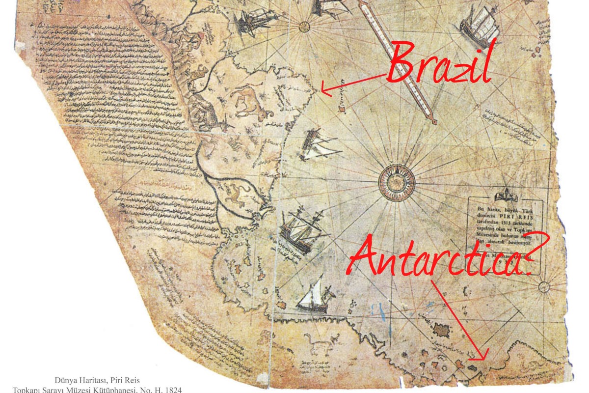
The most debated aspect of the Piri Reis Map is whether it depicts Antarctica — and more significantly, Antarctica without ice. The southernmost part of the map shows a landmass that some interpret as the continent’s northern coastline. If this is true, it would be a groundbreaking revelation since the map was created long before the continent was officially discovered in 1820.
Arguments for the Ice-Free Antarctica Hypothesis
Proponents of the theory that the Piri Reis Map shows an ice-free Antarctica point to several factors:
- The map’s southern landmass resembles modern depictions of Antarctica’s coastline beneath the ice.
- Some researchers claim the map’s accuracy could only come from ancient civilizations with knowledge of pre-glacial Antarctica.
- The shape and placement of the landmass seem to match current depictions of the continent’s geological features.
Counterarguments
Critics, however, are quick to point out the flaws in this theory:
- Many scholars believe the southern landmass on the Piri Reis Map represents South America, not Antarctica.
- The map’s projection and the limitations of 16th-century cartography likely caused distortions that make it difficult to interpret accurately.
- There is no solid evidence to suggest that any civilization before the modern age had access to information about Antarctica’s geography, especially its coastline without ice.
In short, while the ice-free Antarctica hypothesis is intriguing, it remains speculative.
The Origins and Significance of the Piri Reis Map

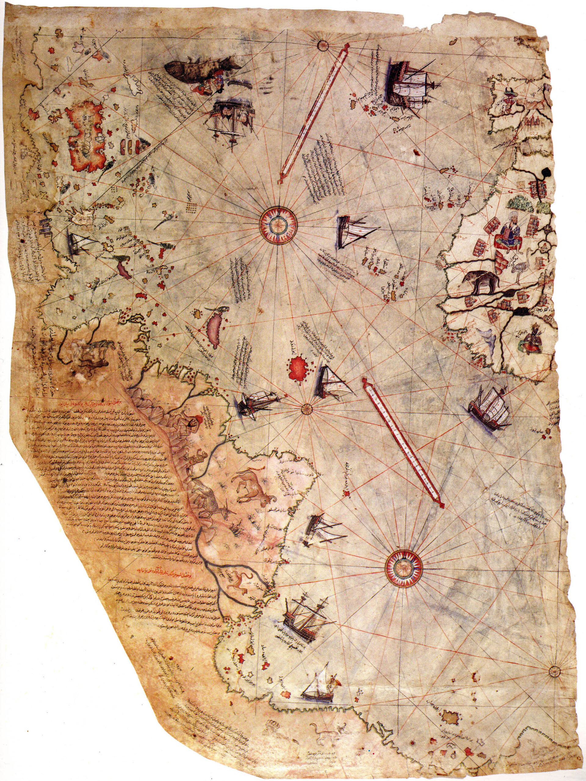
To understand the debate, we need to delve into the history of the Piri Reis Map. The map was created in 1513 by Piri Reis, an Ottoman admiral and cartographer known for his detailed maps of the Mediterranean. Piri compiled the map using information from older sources, including ancient maps and reports from early explorers such as Christopher Columbus.
Key Features of the Piri Reis Map
- The map covers the western coasts of Europe, North Africa, and the New World.
- It contains accurate depictions of the coastlines of South America and Africa.
- The map is famous for its southern landmass, which has sparked theories about it depicting an unknown part of the world, including Antarctica.
Why Is It Important?
The Piri Reis Map is significant not only for its geographical content but also for what it represents: a blend of ancient knowledge and early modern exploration. The map has long been a topic of fascination due to its surprising accuracy and mysterious sources.
Scientific Debate: Is the Piri Reis Map Accurate?
One of the central debates surrounding the Piri Reis Map is whether it is accurate by modern standards. Several scholars have conducted analyses to determine the precision of its coastlines and geographical features.
Support for the Map’s Accuracy
Some researchers argue that the map shows remarkable accuracy, particularly for the southern hemisphere. Supporters of the Antarctica hypothesis cite the map’s southern landmass as evidence, pointing to its resemblance to Antarctica’s coastline.
Criticism of the Map’s Accuracy
However, most historians and cartographers believe that the map’s accuracy has been exaggerated. They argue that the southern landmass more likely represents an extension of South America, distorted due to the limitations of early 16th-century cartography. The map’s creators did not have access to the modern tools required to accurately depict a landmass as remote and unknown as Antarctica.
Exploring the Technology Behind Ancient Maps
How could ancient civilizations create such detailed maps of the world, including areas that were not officially discovered until centuries later? To answer this, we must explore the navigation and mapping technologies available at the time.
Instruments Used in Ancient Cartography

- Astrolabes: Used for determining latitude by measuring the angle between the horizon and a celestial body, such as the sun or stars.
- Compasses: Essential for determining direction.
- Portolan charts: Detailed sailing maps used by mariners, showing coastlines, harbors, and sailing directions.
Despite these tools, it’s unlikely that ancient civilizations had the means to map Antarctica accurately — especially beneath its ice sheet.
Alternative Explanations for the Piri Reis Map
Given the skepticism around the Antarctica theory, several alternative explanations for the Piri Reis Map have emerged.
Did Piri Reis Use Ancient Sources?
Some historians speculate that Piri Reis had access to older maps that were lost to history. It’s possible that ancient civilizations, such as the Phoenicians or Egyptians, had more advanced mapping skills than previously thought, which they passed down to later generations.
Artistic Liberty or Misinterpretation?
Others argue that the map’s southern landmass was a product of artistic liberty or misinterpretation. Cartographers of the time often relied on reports from sailors, who could have exaggerated or misunderstood the lands they encountered. It’s also possible that Piri Reis simply included imagined landmasses to fill in the gaps on his map.
The Lasting Impact of the Piri Reis Map on Modern Cartography
Despite the controversy surrounding its content, the Piri Reis Map has left a lasting impact on the field of cartography.
Influence on Future Explorers
The map inspired later explorers and cartographers, who saw it as a testament to the blending of ancient knowledge and modern exploration. Although its southern landmass remains a mystery, the map is still regarded as an important piece of historical cartography.
Legacy of the Piri Reis Map
The Piri Reis Map continues to captivate historians, geographers, and conspiracy theorists alike. Whether or not it shows an ice-free Antarctica, the map remains a symbol of the enduring mystery of early exploration and ancient cartography.
Separating Fact from Fiction
The Piri Reis Map raises more questions than answers. While the idea that it shows Antarctica without ice is compelling, the evidence remains speculative. Scholars continue to debate the map’s accuracy, and alternative theories abound. One thing is certain: the Piri Reis Map is a remarkable artifact that reflects both the limits and the possibilities of ancient knowledge.
Piri Reis: A Brief Biography
| Name | Piri Reis |
|---|---|
| Born | 1465, Gallipoli, Ottoman Empire |
| Died | 1553, Cairo, Egypt (Executed) |
| Occupation | Admiral, Cartographer |
| Famous Work | Piri Reis Map (1513) |
| Known For | Detailed maps of the Mediterranean & New World |